Airspace summary · Jerusalem

Can you fly a drone in Jerusalem?

  • Last updated:
Place
Jerusalem, city
Centre
31.78°N 35.21°E
Main type
Prohibited area (LLP13)
Data source
Israel AIP (PMAT) · CAAI

Central Jerusalem sits inside a prohibited area — drone flight is not permitted there without special security approval. Over the Temple Mount the restriction is stricter still.

Restriction types that apply within the city

  • Prohibited area (LLP13)The city centre, within a 6 km radius circle, is a prohibited area — from ground level up to 4000 ft. Flight only with special security approval.
  • Temple Mount prohibited area (LLP11)Within it, over the Temple Mount, a stricter prohibited area applies. Where they overlap, the stricter restriction (LLP11) governs.
  • Weekend fly-bubbleNo weekend allowance here. The prohibited area applies at all times, every day of the week.
  • Drone no-fly area (LLU)The city also has drone-only no-fly areas (LLU), on top of the general prohibited area.

Almost the entire city falls inside the prohibited area. A point-specific check matters most at the edges, where the circle may no longer apply.

General airspace guidance as of this date. Not a flight authorization. For a binding check, open the app.

What this means in practice

Central Jerusalem sits inside a prohibited area (LLP13) — a circle of about 6 km radius around the city centre, from ground level up to 4000 ft. Within it, drone flight is not permitted, except for aircraft taking off from an airport operated by the Airports Authority, or with special security approval from the aviation security operations centre. Over the Temple Mount an even stricter prohibited area applies (LLP11), and where they overlap the stricter rule governs. Since almost the whole city is inside the circle, a point-specific check matters mainly at the edges.
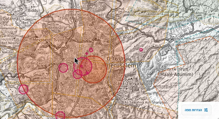
Map of the Jerusalem area in the DroneOps app, with the LLP13 prohibited area as a red circle around the city Captured from the app
Screenshot from the map in the DroneOps app, Jerusalem area. The red circle is the LLP13 prohibited area. Map base: © OpenStreetMap · OpenTopoMap (CC-BY-SA). For illustration only, not to scale.

The rules that apply here

“Jerusalem” prohibited area (LLP13)

What the publication says

LLP13, the prohibited area “Jerusalem”: from ground level up to 4000 ft above mean sea level — a circle of 6 km radius around the city centre.
Israel AIP (PMAT), א׳-17 §1(יג) · summary of the Hebrew sourceSource: airspace publications

Overlap with the Temple Mount (LLP11)

What the publication says

In the part overlapping the “Temple Mount” prohibited area LLP11, the stricter restriction — that of LLP11 — governs.
Israel AIP (PMAT), א׳-17 §1(יג) · summary of the Hebrew sourceSource: airspace publications

The full explanation of the zone types is in the guide: Drone no-fly zones.

More guides