Airspace summary · Eilat

Can you fly a drone in Eilat?

  • Last updated:
Place
Eilat, city
Centre
29.56°N 34.95°E
Main type
Restricted area (LLR27)
Data source
Israel AIP (PMAT) · CAAI

Over Eilat, drone no-fly areas (LLU) apply, and above them a restricted area (LLR27) activated by NOTAM up to high altitude. Drone flight here is heavily restricted.

Restriction types that apply around the city

  • Drone no-fly areas (LLU25 / LLU57)Over the city and the Eilat airspace, areas where drone flight (small UAS under 25 kg) is prohibited.
  • “Eilat” restricted area (LLR27)A restricted area from ground/sea level up to 23,000 ft, activated by NOTAM only. When active, flight is subject to its restrictions.
  • Ramon airport (LLU41)Ramon airport operates near Eilat; a drone no-fly area is defined around its point.

Eilat is next to an international border and to Ramon airport, so the airspace around it is sensitive and restricted. The point-specific check — by point and by NOTAM updates.

General airspace guidance as of this date. Not a flight authorization. For a binding check, open the app.

What this means in practice

Over Eilat and the Eilat airspace, drone no-fly areas are defined (LLU25, LLU57) — areas where flying a small UAS is prohibited. Above them a restricted area is defined (LLR27), from ground/sea level up to 23,000 ft, activated by NOTAM only — that is, it comes into force by notice. In addition, Ramon airport operates near the city, and a drone no-fly area is defined around its point (LLU41). Because some restrictions depend on a NOTAM, it is important to check both the point and the updates before every flight.
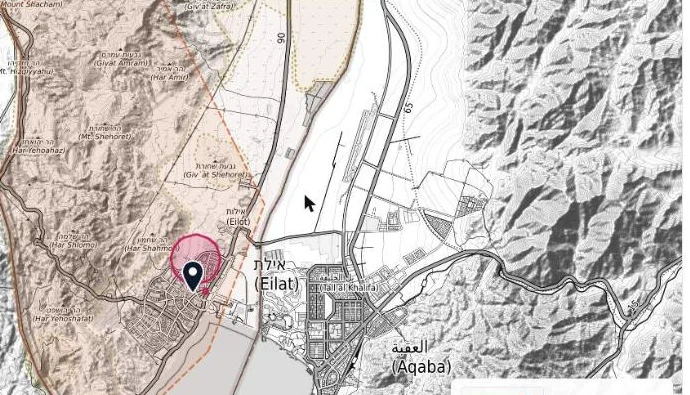
Map of the Eilat area in the DroneOps app, with the airspace layers around the city and the Gulf of Eilat Captured from the app
Screenshot from the map in the DroneOps app, the Eilat area and gulf, with the airspace layers. Map base: © OpenStreetMap · OpenTopoMap (CC-BY-SA). For illustration only, not to scale.

The rules that apply here

“Eilat” restricted area (LLR27)

What the publication says

LLR27, the area “Eilat”: from ground/sea level up to 23,000 ft above mean sea level, activated by NOTAM only.
Israel AIP (PMAT), א׳-17 §2(ה) · summary of the Hebrew sourceSource: airspace publications

“Eilat” drone no-fly area (LLU57)

What the publication says

LLU57, the prohibited area “Eilat”. (From the list of areas prohibited for flight (LLU) for small UAS under 25 kg flown in visual line of sight.)
Israel AIP (PMAT), א׳-17 §1א(ג) · summary of the Hebrew sourceSource: airspace publications

The full explanation of the zone types is in the guide: Drone no-fly zones, and what a NOTAM is — in the NOTAM guide.

More guides